| N23°54.0± E97°39.5± |
Off Topic: Locating Loiwing airstrip(s), Yunnan, China Page 4 of 6 : Miscellaneous Details |
Route NA |
| Text | Notes |
|
1922: Gordon Seagrave, MD, and wife, Marion (nicknamed "Tiny"), having traveled from the south of Burma by river to Bhamo, then moved overland to arrive at Namhkam to take over operation of the Baptist Missionary Hospital there from Dr Robert Harper; the station had been established in 1893, Harper had arrived in 1902, and he had put up a hospital building in 1904. The Survey of India's Bhamo and Hsenwi maps measured the Bhamo-Namhkam distance as 71 miles (114km), which Seagrave traversed by pony and pregnant wife by litter in four days. Those maps show the road to have been metalled.[M01] 1928: Seagrave began a major expansion of hospital facilities which would later help in treating those injured at Loiwing and Suili air facilities in IJAAF attacks at the beginning of the war and in its closing months when the Ledo Road became operational. Completed in 1930, the hospital was named Dr Robert Harper Memorial Hospital.[M02] 1934-1936: Seagrave recorded construction of the Shweli River suspension bridge and improvement of the Namhkam-Bhamo Road. A crude road was built connecting Mong Yu to Chefang (Zhe Fang (N24°15.3 E98°16.8))[M03] 1937: Seagrave recorded that Burma Road construction / improvement moving north, apparently from the Mong Yu (105 Mile point on the road from the railhead at Lashio), and passing through Wanting, had reached Monshi (N24°26 E98°35), well inside China.[M04] Nov 1938: Dan Gourley, advance man for CAMCO, arrived at Namhkam to select a site for the CAMCO factory.[M05] Dec 1938(?): "Chuck" Hunter, CAMCO manager, arrived to begin construction of the CAMCO factory and test runway.[M06] ??? CAMCO facility at Loiwing was completed.[M07] May 1939: Chinese Nationalist government ordered construction of a military airport near CAMCO's test runway.[M08] 26 Oct 1940: IJAAF bombed the Loiwing CAMCO facility. It was subsequently rebuilt as a maintenance and repair facility, nominally for the Chinese Air Force (CAF), in the form of the Flying Tigers, and also the USAAF Ferry Service (cargo) and RAF aircraft.[M09] Oct 1941: Chinese Nationalist airport near CAMCO was completed, with various names applied to the facility: Nanshan, Namsham, Juili, Suili, Shweli, Al-law, Loiwing Aerodrome.[M10] 08 Apr 1942: the first aerial combat over Loiwing occurred.[M11] 01 May 1942: CAMCO facility and Chinese Nationalist airport adjacent were abandoned by Allied forces in the face of the IJA / IJAAF advance into area, and the IJA occupied the sites on 03 May.[M12] 1942-1944: Allied aircraft repeatedly bombed and strafed the area, destroying bridges and other infrastructure, IJA convoys and concentrations.[M13] 06 Jan 1945: CAMCO facility was recovered by Chinese 112 Regiment, 38th Division, advancing from Bhamo.[M14] 15 Jan 1945: Chinese 30th Division occupied Namhkam.[M15] 22 Jan 1945: Muse recovered.[M16] 27 Jan 1945: Mong Yu recovered.[M17] ???: Namhkam airstrip constructed.[M18] ???: Muse fair weather airstrip (Man Wing) constructed.[M19] ???: Muse all-weather airstrip completed.[M20] 15 Mar 1945: Replacement Bailey suspension bridge at Shweli completed.[M21]
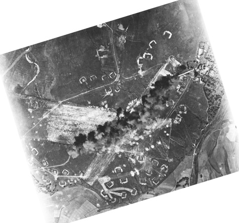
That Suili was Chennault's airfield of choice would be consistent with a later Allied appraisal panning the Factory runway[N01], plus Matt Poole's observations about the general unsuitability of the Factory runway: a hill just off the west end with mountains on three sides.[N02] That was probably the decisive factor in the IJAAF not having repaired / improved the Factory airstrip. That the RAF at the beginning of the war had been relegated to the Factory strip would have been convenient for British crews who were required by Chiang Kai-shek to overnight in Burma, only about 2km away; the coincidence that the Factory strip was the decidedly inferior facility would no doubt have caught Chiang's eye. [SHWEBO] HIT On November 3 [1943], . . . Liberators blasted the runway intersection at Loiwing airdrome, 35 miles southeast of Bhamo in north-central Burma, and tore up the runway on either side of the intersection. . . . By mention of an "intersection", the report confirmed the "airdrome" (Suili) to have been the target, as distinct from the Factory facility.
This photo was by the 7th Bomb Group, 436th Bomb Squadron:[N02a]
Higher resolution image available here Note the curve in the path of the exploding bombs. No notice of that unusual detail was taken; no explanation provided.
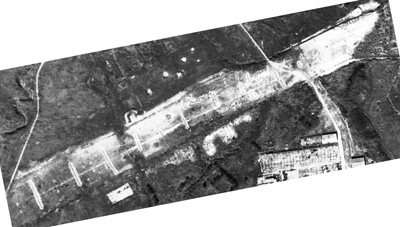
Late in the war, the Japanese placed barriers on the runways in an attempt to make them unusable for Allied aircraft (which also revealed that the IJAAF had no aircraft to use the runways): Loiwing Factory strip:[N03]
Higher resolution image available here.
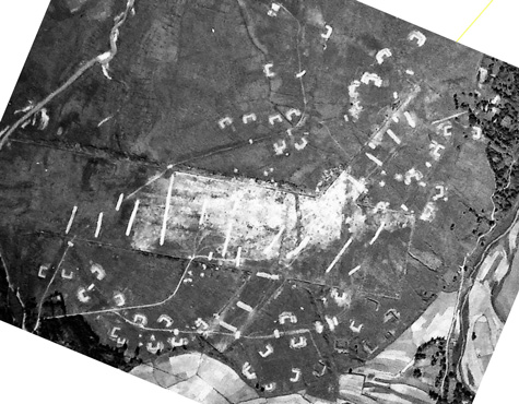
Higher resolution image available here.
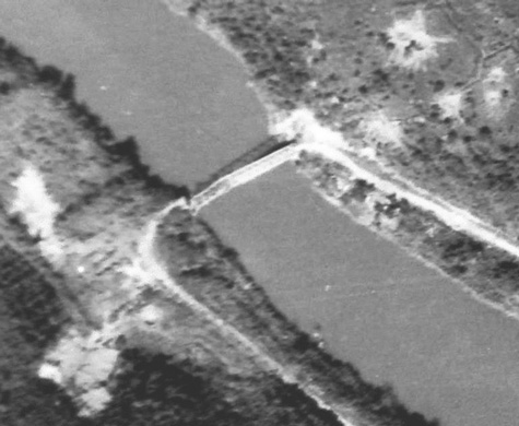
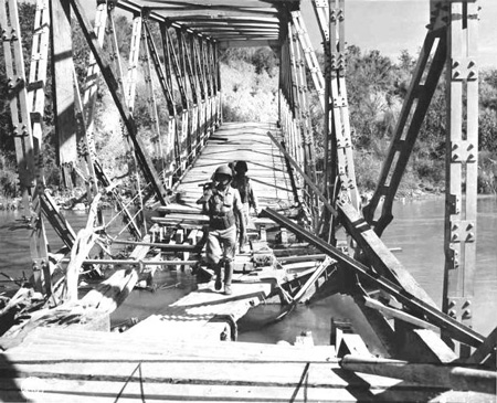
The bridge appears to have been a single span truss of approximate length, 49‑50m (160+ ft), and it was knocked off its westerly abutment, with the top chords of the bridge collapsing at the near third point when that side of the bridge hit the river bottom. Notice that: • The westerly third of the bridge is of uniform dark color
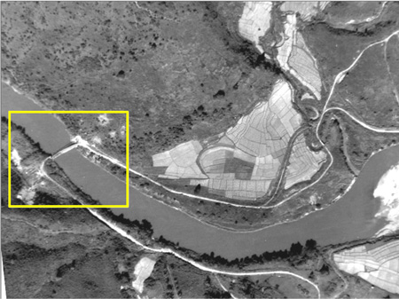
Most likely, the span had been the target of successful Allied bombing: in the aerial photo above, note the scarring on the ground on either side of the bridge: these are probably bomb craters. That photo is an enlargement of the yellow boxed area below: the unblemished countryside outside the box offers a clear unpockmarked contrast to the area immediately around the bridge:[N06]
[Highlights of 1945] JANUARY 1945. Mars Brigade and Chinese troops under NCAC [Northern Combat Area Command] drove south along the route to Lashio and blocked heavy enemy pressure near Wanting. Chinese troops took over the city of Loi-Wing, first place in China to fall to Burma-based troops. shuya的BLOG ~06 January 1945 The Yunnan WWII historian, Ge Shuya, discovered a photo looking from the Burma side into the damaged bridge spanning the Nam Wan:[N07]
Shuya states that the damage had been done by the Japanese, quoting (probably imperfectly, but with meaning clear), the English text written on the photo back (emphasis added): Chinese patrol crossing Jap demolished bridge over Namwan River in[to] China However, I tend to doubt the veracity of the writer of the original text. Much more likely, the Allied concentrated bombing effort targeting bridges noted above was to blame. 879th Engineer Aviation Battalion [?? January 1945] With the continued advance of the "Marsmen" we followed through to Loi Wing, location of an old Curtis Assembly Plant, on to Panghkam and thence to Mu-Se, building the necessary support fields en route. Having now increased our pool of equipment to include a motor patrol, a "D-7 dozer" and carryall, the work of converting the paddies at Mu-Se was a relatively small detail. PATROL ACTION On the Central Burma front, . . . The most noteworthy Allied advance was made by the Chinese 30th Division moving along the Bhamo-Namhkam Road. This force occupied Man Wing, located on Mile 64, seven miles west of Namkham and four miles south of Panghkam. From Man Wing, an all-weather road extends north to Panghkam, then to Loi Wing and on northeast to Wanting.[N07a] Working south from Panghkam, other units have cleared three miles of the road, leaving only one mile unclaimed. Still another force, striking southeast from Panghkam, is nearing the Shweli River and is about three miles from Namkham. Finally, a fourth unit, hitting south just west of the Namkham Road near Man Wing, occupied three villages (Man Maw, Man Hwi and Man Mawn) after Jap patrols moved out. . . .
Chinese troops in the Loi Wing sector are clearing the area north of the Shweli River down towards Namkham. These troops are now about 25 airline miles from elements along the Salween Front, where units captured Wanting, then were driven out by a Jap counter-attack. . . .
U.S. Army headquarters said opening of the new Ledo-Burma Road had been delayed by the Japanese recapture of the border town of Wanting, but Brig. Gen. Marvin Gross, Assistant Chief of Staff for Plans, declared Chinese troops are expected to resume the offensive almost immediately and not only retake Wanting but also strike at the Burma village of Namhkam.
. . . When the Chinese 38th Division cleared Mong Yu ["105 Mile"] on 27 January, Company B, 236th Engineers, rushed in to complete the junction of the Ledo and Burma roads. That same day the 71st Light Pontoon Company put a 450-foot pontoon bridge over the Shweli River at Wanting on the Chinese border. . . .
On 6 February, the C-47 bringing part of our S-3 Section into Mu-Se to survey lines for our job there, overshot the fair-weather field, crashed into the bamboo hedging the south end of the strip, and burned . . . . This fair-weather strip, constructed in the only naturally level spot in the valley floor by our Company "B" detachment, had its approach from over the Shweli River and ended abruptly some four thousand feet away where the foothills crowded in. . . . the [Air Transport Command] had to make the stop to unload personnel, supplies, and pipe for the petroleum engineers laying the "big inch" to Kunming. Another six or eight planes were to crash here before we completed the large runway in the hills above the village. . . . our work at Mu-So [Mu-Se?]. Before long though the only acreage in all that rolling countryside which even looked as though it had the potentials of an airfield, began to have all the earmarks of a good one. Pushing hills into valleys, the D-8’s, D-7’s, pans graders and trucks rumbled through and around the clock schedule. It was higher and cooler here than any of our previous stations. . . . Indeed, looking back now, this period at Mu-Se and Lashio was the beginning of the turning point for us . . . . Mu-Se is about 19km (12mi) northeast of Suili, but south of the border and the Shweli River. With both the Burma Road and oil pipeline on the same side of the Shweli as Mu-Se, it is assumed that the Mu-Se fair weather airstrip was built primarily to support road improvements and construction of the pipeline. The purpose of the permanent airstrip is not clear, but possibly related to providing air access to the 105-Mile intersection (Mong Yu) with the Burma Road, which was 10km (6mi) ESE.
In March, Company B, 209th Engineers completed a 450-foot Bailey suspension bridge over the Shweli River at Namhkam. The opening date is variously listed as 11 March or 15 March.[N08]
|
Emphasis may be added, as relevant, to various excerpts quoted here.
M01.^ Seagrave, ibid, p 25. Baptist mission among the Shan, Ch 2, ibid, p 54. Hsenwi map, ibid. Bhamo (92 H) No. G-47 T, Provisional GSGS [Geographic Service of the General Staff] 4218 (Survey of India), as the 4th Ed 1945-AMS 2 (topo data 1908-12; road classifications Aug 1944). Hereafter Bhamo map. Metalled: "To the military engineer, "metaling" is any substance (usually natural gravel or crushed rock) used to stabilize a road surface in wet weather." Per Anders, Leslie, The Ledo Road (Norman: University of Oklahoma Press, 1965), p 9. M02.^ Seagrave, ibid, p 70ff. Baptist mission among the Shan, ibid, p 61 M03.^ Seagrave, ibid, p 76. M04.^ Seagrave, ibid, p 79. Lieuwe Montsma email of 1350 hrs 25 Dec 2014. M05.^ Seagrave, ibid, pp 94-95. M06.^ Seagrave, ibid, pp 95-96. M07.^ Reference needed. M08.^ Per description by Li‑yan, Yunnan Museum Archives, to Wang Min and Lu Min by email. Document was subsequently forwarded to Dan Ford, who passed it to me. Hereafter: Wang Min document. M09.^ Ford, Daniel, Flying Tigers (Washington: Smithsonian, 2007), p 29. M10.^ Wang Min document. M11.^ Ford, ibid, p 259. M12.^ Ford, ibid, pp 285, 287. M13.^ Hammel, Eric, Air War Pacific Chronology (Pacifica Military History (Kindle Edition), 2009). M14.^ Romanus, CF, and R Sunderland, Times Runs Out In CBI (Washington: Center of Military History, US Army, 1999), Map 7: Opening the Road to China, p 124. M15.^ Seagrave, Burma Surgeon Returns (NY: Norton, 1946), pp 238-239. Conversely, Chinese Army India-Burma Campaign IV states: On the morning of December 15 [1944], the Namhkam Valley was enveloped in a thick fog. The 90th Regiment marched through the fields into the town of Namhkam, which was fully captured before noon that day. M16.^ Stilwell Road. M17.^ Ibid. M18.^ Pictured as "The WWII Airstrip at NamKham [sic]" on A Study Trip to the Ledo Road. Unfortunately no coordinates are provided. One possible location suggested by Lieuwe Montsma: N23°50.37 E97°42.17 M19.^ Pictured as ". . . near Man Wing" in The War against Japan, Pictorial Record, Section V, China-Burma-India. Location: ~N23°59.0 E97°53.5. M20.^ Assuming "Mu-So" is "Mu-Se", from 879th Engineer Aviation Battalion, Location: N24°00.55 E97°55.11. M21.^ CBI Order of Battle: 209th Engineer Combat Battalion.
N01.^ Extract from Airfield Report No 21, April 1944, p 2 (USAF Archive microfilm roll A8055, p 0628). N02.^ Matt Poole email of 1119 hrs 01 Nov 2014. For example, see Note on hill location. N02a.^ Fold3. NARA Reference Number: 342-FH-3A02677-123039AC. Item added 07 Apr 2015. N03.^ Extract from NARA F1309, Frame 102, 13 Nov 1944; image courtesy of Matt Poole (image MP9459 by email of 0653 hrs 12 Dec 2014). Image extracted, rotated so north is up-page, and enhanced with IrfanView by author.
N04.^ Extract from NARA film can F1309, Frame 100, 13 Nov 1944; courtesy of Matt Poole (image MP9469 by email of 0653 hrs 12 Dec 2014). Image is extracted, rotated so north is up-page, and enhanced with IrfanView by author. For additional information on the bridge, see Locating the border bridge.
N05.^ Extract from NARA F1309, Frame 100, of 13 Nov 1944; courtesy of Matt Poole (image 9469 per email of 0653 hrs 12 Dec 2014). Image is extracted, rotated 6° cc so north is up-page, and enhanced using IrfanView, by author.
N06.^ Ibid. Annotation by author using Microsoft Publisher.
N07.^ Photo titled 章东磐团队图片 in shuya的BLOG: 进入中国的车队如何跨国瑞丽江?. Note the shadows show the sun to have been on the right which would be generally south; hence the camera was looking easterly. The photo could have been taken as early as 06 Jan 1945, when the 112th Regiment, traveling southeast and following the eastern shore (the China side) of the Nam Wan, entered Loiwing. In this photo, Chinese troops were moving from China back into Burma; the reason for the troops going back to Burma is not clear. Ultimately the 112th Regiment continued southeast along the easterly shore of the Nam Wan, to cross the Shweli River directly across to Namhkam.
N07a.^ But see Seagrave's non-existent "Alternate Route".
N08.^11 March: Ge Shuya in 进入中国的车队如何跨国瑞丽江? 15 March: CBI Order of Battle: 209th Engineer Combat Battalion.
|